| OGSR Wireline
By OGSR Library April 2018
|
Hi ,
Welcome to the second quarterly edition of OGSR Wireline 2018.
This edition is loaded with new data updates! See what's happening now in Ontario, read an exciting guest submission by Union Gas, and see a preview of how the Library has been building GIS Communities.
Let us know if you have any requests for future articles, and in the
meantime,
Keep exploring,
OGSR Library Team Jordan, Liz, Matt, Maia, Craig & Ben |
How Did Oil and Gas Producers Fare in 2017? Get a sneak peak at the early numbers for last year, then get inspired with some exclusive free reports!
| The OGSR Library has been busy, let Maia and Craig update you on what's been going on.
|
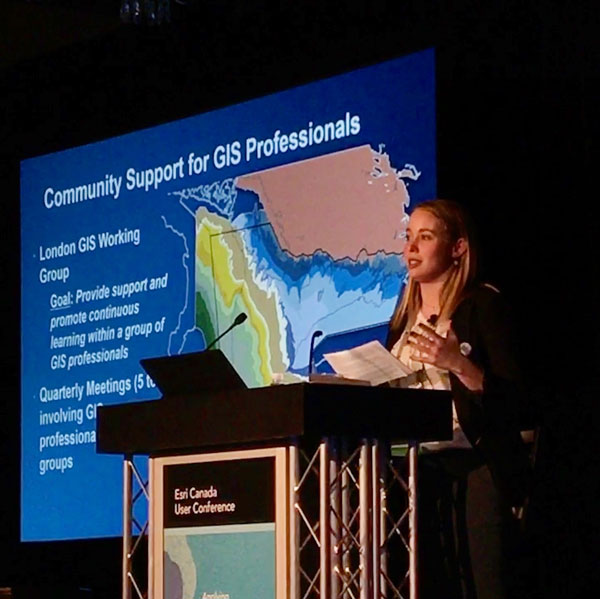
Building GIS Communities Feature from Esri Canada User Conference
Presentation
Safety and Innovation Go Hand-in-Hand with Pipe Viper Technology Union Gas
|
OGSR Library Media Update
by Matt
Monthly Drilling Report -
March 2018 by OGSR Library Team |
Save the date for EPEX 2018: OPI's 56th Annual Conference, details below!
Continue Reading for Full Stories
How Did Oil and Gas Producers Fare in 2017? By Jordan
Oil and natural gas production forms are submitted on February 15th of each year for monthly production in the previous calendar year. Once the forms
have been audited by the regulator we can begin to drill in to the data for insights about activity in the previous year. As of this newsletter 55% of oil and 77% of natural gas production, by volume, has been made available to the Library. The data presented below represents a projection based on the reporting that has been received. With 55% of oil producers reporting by volume (relative to 2016) a total of 29,571 cubic meters of oil production was reported. For the same operators in 2016 production was 31,428 cubic meters, a difference of 1,857 cubic meters. Extrapolating the difference to all reports 2017 would see final production near 53,507 cubic meters of oil (336, 547 barrels). Ontario’s largest oil producer is included in the figures. With 77% of natural gas producers reporting by volume (relative to 2016) a total of 110,435 thousand cubic meters of gas have been reported. The same operators produced 119,122 thousand cubic meters of gas in 2016, a difference of 8,687 thousand cubic meters. Extrapolating the difference to all reports would mean production of
143,984 thousand cubic meters (or 5.1 BCF) in 2017 (see Table 1 below).
Table 1: Estimate of 2017 Production Volumes Based on Available
Reporting
The 5.9% decline
in production in table 1 above from 2016 to 2017 is much smaller than the 14% decline reported from 2015 to 2016, if the projection holds for the remaining 45% of reports still to be submitted. Natural gas declined 7.3% from 2016 to 2017, which is slightly more than the 5% decline recorded from
2015 to 2016. Commercial drilling in 2017 was primarily limited to natural gas storage wells, which are a remarkable success story for Ontario with 278 BCF of gas storage capacity available. Newly issued licences on the Library website indicate the trend to drilling natural gas storage wells will continue in 2018. New commercial oil and natural gas wells may also be seen in 2018 and with some luck current trends in production could be slowed or reversed. Each year the Library produced many new datasets and tools for exploration. Get a head start on your exploration with these (free!) reports: (s3.amazonaws.com/downloads.ogsrlibrary.com/open/Comprehensive-Engineering-Study-of-Columbus-Reservoir--Rodney-Field.pdf)
For Exploration: Have a look at this members’ only report on Ordovician resources potential ($500 value). Up to half of all oil in this play may be undiscovered (www.ogsrlibrary.com/downloads/Ontario%20Potential%20Hydrocarbon%20Resources%20Ordovician%20Hydrothermanl%20Dolomite%20Play.zip)
The Subsurface Paleozoic Stratigraphy of Southern Ontario contains detailed formation descriptions, wells logs, color photographs, and large
fold-out charts.
www.ogsrlibrary.com/sv7
We look forward to helping you with any of your Ontario (or nearby) projects! Geology Project Updates By Maia and
Craig
This year the OGSR Library team has been working hard to produce extensive new geological datasets for members! Projects involving water record analysis, the data entry of permeability files, and updates to Form 10 records are only some of the many datasets that
will become available over the next year. The effort of the Library and organizations such as the Ontario Geological Survey (OGS), the Geological Survey of Canada (GSC) and the Ministry of Natural Resources and Forestry (MNRF) over the last few years has greatly increased the reliability and accessibility of information in petroleum records. Much of the work completed for these projects involves the transfer of information from paper records to spreadsheets. Paper records are useful but they are
not nearly as accessible as a database that can be queried. The OGSR Library recognizes the value of digitizing data. The digitization of data increases the usability of information so it can be queried for quality assurance or to create spreadsheets customized specifically for the user. Permeability Database The OGSR Library has been preparing a database digitizing the analysis of 476 rock cores from wells in Ontario. The database has over 27,000 lines of data reporting parameters of permeability, porosity, fluid saturation, and grain density for each interval analyzed. Permeability data can be used to inform flow capacity and gravity drainage
potential, whereas porosity data provides an indication of the storage capacity of the rock. Fluid saturation of oil and water were analyzed and can imply the presence and quantity of these fluids within a reservoir. Finally, grain density can be used to confirm the mineralogy of the core. This
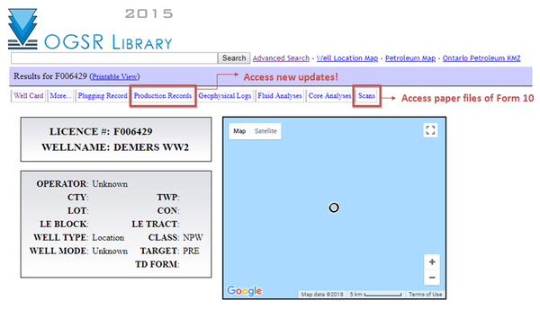
database will compliment the 10,000 core photos that include dry, wet and ultra-violet photos, which can be used to identify the presence of hydrocarbons. Form 10 Records Work is underway to update some of the details from Form 10 records that are stored in the digital database. Some parts of the plugging and completion records (Form 10) were incomplete in the database making analysis difficult without referring to the paper records. This project involved a thorough review of the Form 10 scans, and extensive data entry to fill in missing information.
Review of the data for over 1,300 plugging records has been completed and the findings will be summarized in a published Open File Report. All updates are now available to members through the online well cards under the Plugging Records tab and scans of all Form 10s are available under the Scans tab of the well card, as before. Water Record Analysis The water record analysis involved the mapping of the base of the sulphur water beneath the subsurface of Southern Ontario. The base of fresh water marks the depth at which water is no longer potable. The findings of this report will summarize the isolation of hydrologic systems in Southern Ontario’s subsurface, the widespread occurrence of groundwater
types, and the overall reliability of the water record database. Water records were taken from over 35,000 records in Ontario Petroleum Data Systems (OPDS) to produce a regional maps displaying the interface of the base of salt and sulphur water. An Open File Data Release by Terry R. Carter and Liz Sutherland will be made available for download by the GSC soon. The results of this study can be used as a tool to support research to understand flow patterns in subsurface bedrock formations of
Southern Ontario.
Be sure to keep an eye out for these exciting data releases coming soon! If you are interested in learning more about OGSR Library projects, or have any questions about where to find this data please
do not hesitate to contact us. Building GIS Communities Liz Sutherland Presented at the Esri Canada User Conference, April 4th, 2018
In recent years, the OGSR Library has created a precedent for promoting and providing support for
GIS within London. This push was inspired by the ESRI Canada Ambassador program, through which the Library became involved with in 2016. Through their support, the OGSR Library has coordinated an annual GIS Open House, bringing together ~150 people over a two year period. In addition, the Library has spearheaded a London GIS Working Group. This group meets once a quarter to discuss ongoing GIS initiatives and to offer support to the traditionally small GIS ‘departments’ within London workplaces
through software troubleshooting and workshops. The Ambassador program’s access to ArcGIS Online has further allowed Library staff to teach GIS skills to local high school students. ESRI Canada’s objective to ‘leverage the power of geography’ exists in each of these activities, as the Library works to build a network of support for GIS within London.
What do you do for a living? We are asked this question all the time, and as GIS professionals we have a harder time answering this than most other people. So, we tend to be quite good at defining GIS to a wide range of audiences. I myself have several go-to definitions…
And always intrinsic in my definition is the idea of GIS as a system for bringing together geographic/spatial data. My definition for GIS communities comes from this idea of GIS as a system. A GIS community is a system of support for bringing together spatial knowledge and the people who support the growth of spatial knowledge. This idea can be applied at any scale, however my involvement comes in at the local level where Esri has things wrapped up nicely for the larger regional/national scale. Thanks to Esri GIS is everywhere. So why don’t people know what GIS is? Why do we still have to answer the
question “What do you do for a living” with an Intro to GIS lesson? Almost every industry, every business uses a GIS professional in some capacity (and if they don’t, they should!). The common link between each of these people, no matter what industry or business is Esri, never before has a profession been so strongly linked to a single software package. So how do we connect these professionals? Esri Canada promotes GIS Nationally through GIS Day and
the “ArcUniverse”, supports GIS through User Conferences, encourages GIS education through all their initiatives spearheaded by their Education & Research Department. But there is an opportunity here to extend these ideas, because… What if I don’t use ArcGIS or Esri products? What if I’m a high school student who’s never heard of GIS? What if I work
for a non-profit that can’t send me to the user meetings I need to attend? The OGSR Library saw this as an opportunity to apply Esri’s frameworks for GIS promotion, support and education on the local-scale to create a GIS Community.
Promotion
The first category of my framework, promotion of GIS, has been achieved through the GIS Open House. GIS Day was something I had been involved in while at Western,
and what I noticed while I was there was the limitations of the event. There wasn’t one venue that was truly Open to All.
The first event had 40 attendees and 6 partners, and was received positively by all participants. Enough so, that I was able to establish it as an annual event. In 2017, we doubled our numbers. I formatted the Open House
to try and bring together GIS users from across London to exhibit their GIS projects through interactive displays. This interactive element is extremely important to me, because this is how GIS can be best taught to those who aren’t familiar with it. The displays in this years Open House were spread throughout the library and included
MNRF, MTO, Upper Thames River CA, MOECC, Western Geography, and City of London who all brought a different interactive display to showcase how GIS is being used around London. Adding this tactile element to the event creates a heightened level of interest for participants. And is just more fun than
static displays. I really wanted this event to provide the public with a space to explore and learn about GIS and spatial technologies, openly and interactively. The event was made completely free and was open to all ages and levels of GIS understanding. Prizes and swag were donated by Esri Canada. These types of events are key in providing an environment to learn and experience GIS technologies, and contributes greatly to my framework for building GIS communities.
The collaborators I’ve been able to work with over the past 2 years have made me confident that this event will continue to grow and strengthen London GIS and I am extremely excited for next years event planning.
This year’s event will be held November 23rd! Community Support Many GIS professionals work in small groups or as
the sole GIS specialist for their business or department. I felt like these individuals, myself included, needed a way to connect with other GIS professionals more regularly. The London GIS Working Group's goal is to “Provide support and promote continuous learning.” We now hold quarterly meetings that involve GIS professionals from 9 groups. What has really helped the members through these meetings is being
able to share knowledge and solutions to roadblocks other members may be facing, such as where to find certain data, what tools to use to solve spatial problems as well as discussions about training summer students.
Education The GIS Ambassador program perfectly rounds out my framework. Esri Canada has done an amazing job providing resources to teach GIS in schools across the country. By joining the Ambassador program I have had the opportunity to lead lessons and GIS Tutorials for local high schools. The lesson resources I have developed complement the resources provided by the ArcGIS Online community and have helped to spark an interest for GIS in the next
generation.
Some of the students I’ve taught have even volunteered to help with the Open House event. As well as participate in the GIS Skills Competition.
GIS Communities provide so many benefits to the growth and development of GIS. Each of the elements of my framework contribute to my new life motto…. “Spatial Knowledge Should be Common Knowledge.” Esri Canada uses ArcGIS Online to build a web-GIS community and uses ArcMap/ArcPro to create a common language. Bringing these Esri Canada values
and ideas together at the local scale: - Provides support to users working independently
- Promotes GIS as a tool to non-GIS users
- Spreads awareness and knowledge of GIS to students
Outlining how I have tried to do this within London will create guidelines and ideas that can be applied to other communities. One day, Spatial Knowledge WILL BE Common Knowledge
What’s
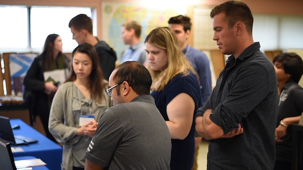
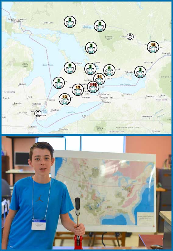
Next? Building GIS communities should involve the GIS community, so if you have ideas reach out to me so we can work together to promote the “Science of Where." GIS Day Open House 2017 - Media Release Matt Dupont
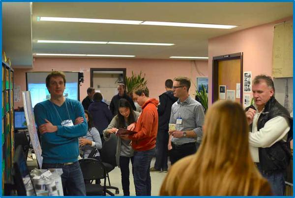
Back in November the OGSR Library hosted the 2017 GIS Day Open House. This is an annual event hosted by the library to coincide with GIS Day. Our very own GIS ambassador Liz Sutherland worked hard to coordinate the event which was a smashing success. We had about 90 people show up,
which was doubled from the previous year’s attendance. We hope the event will continue to grow (we might need a bigger venue).
I had the pleasure of attending and
roamed around with a camera to ask what everyone was up to. The following video gathers some interview clips, footage, still photos, and even a time lapse that shows just how happening the event was. Hope to see you at the next one this coming November!
Click the image below to view the video!
Upcoming Media Releases in 2018:Historical Lake Rig Footage: Footage
of rigs on Lake Erie from the mid 1980s. We’ve had these Super 8 film reels transferred to digital and they look great. We will be premiering several minutes of footage at this year’s OPI conference (May 14-15) and will be making all of it available to view soon after that.
Industry Interview Clips: Some informal thoughts on how we can grow the industry taken from this years MNRF Industry Open House.
OGSR Library Tutorials: Can’t figure out how to find something from our website? Don’t feel like calling to ask (we’re always here to help!)? Or maybe you didn’t even know something you were looking for was there all along? We’re designing a series of tutorial videos to help our members make the most of their membership.
Stay tuned!
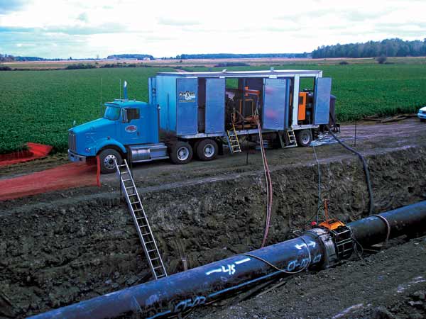
Safety and Innovation Go Hand-in-Hand with Pipe Viper Technology Union Gas continuously seeks new and innovative ways to safely and
reliably deliver natural gas to its customers. Their ongoing search for technological advancement is one driven by efficiency, effectiveness, and of course, safety. As a company dedicated to the sustainability and growth of the natural gas industry, they feel it’s important to support companies and technology that can further benefit employees and customers while remaining dedicated to environmental and personal health.As part of its focus on safety and reliability, Union Gas inspects assets on a regular basis, such as their natural gas pipelines. The company actively identifies, removes and replaces outdated natural gas pipe.
When conducting this work, Union Gas is aware that outdated pipes and their coatings may contain hazardous contaminants
such as asbestos and PCBs. The traditional method to remove old pipe coatings is called “media blasting” – a process which uses air pressure tools. However, this runs the risk of contaminants becoming airborne which can pose a health risk to employees working in the area and could potentially spread to surrounding areas, putting others at risk. Whether in terms of personal or environmental safety, Union Gas is committed to ensuring all of its worksites are safe, and that environmental integrity
is preserved. Union Gas has recently adopted a new technology that will replace media blasting called Pipe Viper, which is proving to be safer for employees and
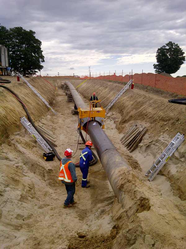
the environment. Pipe Viper is a cost effect, portable, self-contained system which uses ultra-high pressure water to strip and remove the coating from pipe, while a high powered vacuum gathers any material that is removed. It then filters the contaminants in a closed-loop system and stores the resulting waste product in a completely isolated unit. (Figure 1)
Figure 1: Pipe Viper Self Contained
System
According to Shawn Khoshaien, director, Engineering at Union Gas, Pipe Viper technology significantly reduces exposure
risks associated with coating removal. Rather than using hand tools which can cause ergonomic strain, workers simply have to install Pipe Viper hardware onto the pipe and allow the self-driving system to complete the coating removal. An added benefit is its ability to limit the number of people required to complete the job while also minimizing the strain on an individual’s body. (Figure 2) Figure 2: Pipe Viper machine stripping old pipe leaving behind a smooth pipe with no coating on the surface
This new technology is offered through Automatic Coating Limited (ACL), located in Scarborough, Ontario. ACL is well known in the industry, as the company operates state-of-the-art equipment and processes for liquid, powder, shop and field-applied coatings in both Canada
and the United States. A Note From Ben Ben
Somers
|
I started working here as a co-op student at the beginning of the semester however, it was not the first time I had been at the OGSR Library. Last year in November, I volunteered for GIS day to greet people at the door for the day and if you showed up, there's a good chance that you saw me. My first impression of the library was that the people are very kind, and also that they are very dedicated and
interested in their work. On GIS day I had a lot of questions and the staff were happy to answer them. Over the last few months I have had a great time working here and have learned a lot about the inner workings of the petroleum industry. For example, the vast amount of wells that are on record.
When I started working here, I was put to work almost right away on an important project where I was to iterate through core analysis scans and digitize the data pertaining to permeability and porosity; another step in the process of transitioning our data from the paper age to the digital age. This project was a very
large task to take on. Luckily, I had the help of my coworkers, and friends, Craig, Bayden, Maia, and Evan. Doing this project gave me a rich sense of purpose and I was almost sad to see it complete.
Now that the core analysis project is complete, I have been working on another very interesting and fun task. My favorite hobby is to produce music and I do it all the time. Maia, my sister, knows this and let people know. So, Jordan thought that it would be a good idea to put my skills to good use and have me produce music to go over
some videos that Matt made for the upcoming conference on May 15th. This is an exciting opportunity and I am really glad that I got hired to be a co-op student here.
|
March 2017
New Licences Issued
| Licence No. | Issue Date | Operator | County | Township | Status | TD (m) | | | 1682468 Ontario Inc. | Lambton | Moore | LIC/NDR | |
No New Licenses Issued for Existing Wells
Wells Plugged
| Licence No. | Plug Date | Operator | County | Township | Status | TD (m) | | | Enbridge Gas Distribution Inc. | Lambton | Moore | NGS/ABD | 699.82 | | | Enbridge Gas Distribution Inc. | Lambton | Moore | NGS/ABD | 675.70 | | | Dieker, Henk & Ans | Elgin | Aldborough | GP/ABD | 1171.35
| | | On-Energy Corp. | Elgin | Aldborough | GP/ABD | 1241.00 |
|
| Energy Prospectors Expo
(EPEX)
NOW ACCEPTING!! Student poster contest submissions
May 14th
May
15th Conference Theme: Generating Collaborative
Energy
|
Day 1: May 14th Length | Time | Event | Presenters | 4 hr | 12:00 | Booth Setup |
| 1 hr | 4:00 | Energy Collaboration Showcase | OPI, MNRF, OGSR Library | 3 hr | 5:00 | Icebreaker |
|
Day 2: May 15th Length | Time | Event | Presenters | 60 min | 7:00 | Breakfast |
|
|
| Poster Set-up |
| 15 min | 8:15 | Official Conference
Opening |
| 45 min | 8:30 | Plenary | MC: Maia Somers, Conference Chair: Ian Colquhoun, OPI: Hugh Moran, OGSRL: Jordan
Clark |
|
|
|
| 30 min | 9:15 | Morning Coffee Break and Poster
Judging |
|
|
|
|
|
|
| BLOCK 1: ENERGY
STORAGE | MODERATOR - CHELSEA UNGAR | 20 min | 9:45 | "Compressed Air Energy Storage in Salt Caverns" | Eric Tharumalingam – U Waterloo | 20 min | 10:05 | “Natural Gas Storage – The Dawn Hub” | Mike Learn – Union Gas | 20 min | 10:25 | “Hydrogen Storage in Depleted Natural Gas Reefs” | Dave Thompson - Northern Cross | 15 min | 10:45 | Block 1 Panel Discussion |
| 15 min | 11:00 | Intersession Break
|
|
|
|
|
|
|
| BLOCK 2: HYDROCARBONS | MODERATOR - CHELSEA UNGAR | 20 min | 11:15 | “The Ontario Opportunity” | Laurent de Verteuil | 20
min | 11:35 | "Petrophysical Properties of the Rock Record" | Phil McCausland - Brock U | 20 min | 11:55 | "Gedex High Definition Airborn Gravity Gradiometer - Potential for SWON" | Brian Main - Gedex Earth | 15 min | 12:15 | Block 2 Panel Discussion |
|
|
|
| 90 min | 12:30 | Lunch Break |
|
| 1:00 | Keynote Speaker | Sherry Pineo |
|
|
|
| 10 min | 1:45 | Student Poster Awards |
|
|
| BLOCK 3: ENVIRONMENT AND RISK MANAGEMENT | MODERATOR - ELISHA PERSAUD | 20 min | 2:00 | "Hydrocarbon Storage in Porous Rock Reservoirs and
Salt Solution Mined Caverns in Ontario" | Jug Manocha - MNRF | 20 min | 2:20 | TBD | Shawn Williams – Indian Oil and Gas Canada | 20 min | 2:40 | "Omaha! A Pundits Playbook to In-Situ Remediation of PHCs" | Gary Winthrop - Matrix Solutions (Calgary) | 15
min | 3:00 | Block 3 Panel Discussion |
|
| 3:15 | Afternoon Coffee Break |
|
|
|
|
| | | Ballroom & Exhibit Hall | 45
min | 3:30 | Terry Carter / Liz Sutherland & Maia Somers | | | 3D Geological Modelling and Core Preview | 10 min | 4:15 |
| Closing Remarks - Wine and Cheese Start | 2 hrs | 5:00 |
| Exhibit Hall Closes/Tear-down |
|
|
|
| 3 hrs
| 7:00 | Brewery Tour & Networking | London Brewing Co-Op |
|
If you are having trouble viewing this newsletter, it can be viewed here.
What is the OGSR Library?
The Ontario Oil, Gas & Salt Resources Library is a not-for-profit corporation that manages all of Ontario's public drilling and production data from the petroleum and solution mined salt industries. This includes processing, storing, and providing safe and convenient access to all of the industry's drill core
and rock cuttings. The Library makes as much of this data as possible available through our online portal to members all over the world. The financial support of the petroleum industry and our membership make this possible.
|
Follow:

|
|
|
|
|